Lake Mead Drops to a Record Low

Lake Mead is the largest reservoir in the United States and part of a system that supplies water to at least 40 million people across seven states and northern Mexico. It stands today at its lowest level since Franklin Delano Roosevelt was president. This means less water will be portioned out to some states in the 2022 water year.

As of August 22, 2021, Lake Mead was filled to just 35 percent of its capacity. The low water level comes at a time when 95 percent of the land in nine Western states is affected by some level of drought (64 percent is extreme or worse). It continues a 22-year megadrought that may be the region’s worst dry spell in twelve centuries.

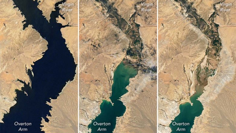
These natural-color images were acquired in August 2000 and August 2021 by Landsat 7 and Landsat 8. The tan fringes along the shoreline in 2021 are areas of the lakebed that would be underwater when the reservoir is filled closer to capacity. The phenomenon is often referred to as a “bathtub ring.”

The lake elevation data below come from the U.S. Bureau of Reclamation, which manages Lake Mead, Lake Powell, and other portions of the Colorado River watershed. At the end of July 2021, the water elevation at the Hoover Dam was 1067.65 feet (325.4 meters) above sea level, the lowest since April 1937, when the lake was still being filled. The elevation at the end of July 2000 was 1199.97 feet (365.8 meters).

At maximum capacity, Lake Mead reaches an elevation 1,220 feet (372 meters) near the dam and would hold 9.3 trillion gallons (36 trillion liters) of water. The lake last approached full capacity in the summers of 1983 and 1999. It has been dropping ever since.
In most years, about 10 percent of the water in the lake comes from local precipitation and groundwater, with the rest coming from snowmelt in the Rocky Mountains that melts and flows down to rivers, traveling through Lake Powell, Glen Canyon, and the Grand Canyon on the way. The Colorado River basin is managed to provide water to millions of people—most notably the cities of San Diego, Las Vegas, Phoenix, and Los Angeles—and 4-5 million acres of farmland in the Southwest. The river is allotted to states and to Mexico through laws like the 1922 Colorado River Compact and by a recent drought contingency plan announced in 2019.

With the Lake Mead reservoir at 35 percent of capacity, Lake Powell at 31 percent, and the entire Lower Colorado system at 40 percent, the Bureau of Reclamation announced on August 16 that water allocations would be cut over the next year. “The Upper [Colorado] Basin experienced an exceptionally dry spring in 2021, with April to July runoff into Lake Powell totaling just 26 percent of average despite near-average snowfall last winter,” the USBR statement said. ”Given ongoing historic drought and low runoff conditions in the Colorado River Basin, downstream releases from Glen Canyon Dam and Hoover Dam will be reduced in 2022 due to declining reservoir levels. In the Lower Basin the reductions represent the first “shortage” declaration—demonstrating the severity of the drought and low reservoir conditions.”

For the 2022 water year, which begins October 1, Mexico will receive 80,000 fewer acre-feet, approximately 5 percent of the country’s annual allotment and Nevada’s take will be cut by: 21,000 acre-feet (about 7 percent of the state’s annual apportionment). The biggest cuts will come to Arizona, which will receive 512,000 fewer acre-feet, approximately 18 percent of the state’s annual apportionment and 8 percent of the state’s total water use (for agriculture and human consumption). An acre-foot is enough water to supply one to two households a year.


Report: Without Action, NC Will Fall Short on 2025 Climate Goals

Play

Tuesday, April 26, 2022

Executive orders aimed at driving down greenhouse-gas emissions are still not enough to reach North Carolina’s 50% reduction goal by 2030, a report by the Environmental Defense Fund found.

The report showed under current state policies, North Carolina is on track to shrink emissions by 28% to 38%, far below its target.

Michelle Allen, project manager of North Carolina political affairs for the Environmental Defense Fund, said there are ways to get back on track, including aggressively building greener infrastructure for electric power and public transportation.

“The electric power and the transportation sectors account for nearly 70% of the state’s overall climate solutions,” Allen pointed out. “Those are going to be the top two, really most critical, sectors to focus on.”

The governor’s executive orders require reducing energy consumption in state-owned buildings and increasing the number of zero-emission vehicles on the roads.

Allen explained North Carolina’s utility commission, which is responsible for regulating electric utilities, is also in the process of developing a carbon plan.

“Which is going to outline how the electric-power sector is going to drive down climate pollution in line with these 2030 and 2050 targets,” Allen noted.

According to the state’s Department of Environmental Quality, poor air quality is largely driven by vehicle emissions triggering ground-level ozone or smog, and particle pollution.

Allen added taking steps to curb emissions will improve residents’ health, especially those who are most vulnerable.

“The next step after that is to determine the policy solutions and programs that are going to get us to achieve those goals,” Allen asserted.

Research shows on a local level, air pollution from manufacturing and industry is most commonly concentrated in low-income neighborhoods and communities of color.

Disclosure: The Environmental Defense Fund contributes to our fund for reporting on Energy Policy, Environment, Environmental Justice, and Health Issues. If you would like to help support news in the public interest, click here.

Winter Weather Advisory

Alert Details

Advisory: Winter Weather Advisory until 10:00AM

* WHAT…Freezing rain. Additional ice accumulations of a light glaze.

* WHERE…Portions of the North Carolina Foothills.

* WHEN…Through 10 AM EST Monday.

* IMPACTS…Very slippery sidewalks, roads and bridges are possible. The hazardous conditions could impact the morning commute.

* ADDITIONAL DETAILS…Temperatures are expected to warm quickly during the middle part of the morning thus limiting the potential for ice accumulations.

* AFFECTED AREAS: ALEXANDER … CLEVELAND … CALDWELL MOUNTAINS … GREATER CALDWELL … BURKE MOUNTAINS … GREATER BURKE … MCDOWELL MOUNTAINS … EASTERN MCDOWELL … RUTHERFORD MOUNTAINS … GREATER RUTHERFORD

Instructions:

A Winter Weather Advisory for freezing rain means that periods of freezing rain or freezing drizzle will cause travel difficulties. Be prepared for slippery roads. Slow down and use caution while driving. Please report snow and ice accumulations by calling the National Weather Service toll free at…1…800…2 6 7…8 1 0 1. Leave a message with your observation and the specific location where it occurred. You can also post your report to National Weather Service Greenville Spartanburg Facebook or tweet your report using hashtag nwsgsp.

Stay tuned to NOAA Weather Radio or your favorite source of weather information for the latest updates. Additional details can be found at www.weather.gov/gsp. The latest state road conditions can be obtained by calling 5 1 1.

Gov’t. Depts. closed due to weather

Rutherford County Sheriff’s Office administrative offices will be closed tomorrow, January 18, 2022, due to inclement weather.

All Rutherford County Offices, Convenience Centers, and Landfill will be closed for operations on Tuesday, January 18, 2022.

Rutherford County Transit will be closed. All transportation is cancelled due to weather.

The Rutherford County Senior Center will be closed and will not be serving meals.

Rutherford County Courts will not be in session Tuesday, January 18, 2022.

Emergency services such as law enforcement, fire, and medic will be operating as usual.

If you have an emergency, call 911. For all non-emergencies, call 828-286-2911. The roads are still hazardous and non-essential travel is not advised. If you must travel, please use caution. Drive slower than usual, increase your following distance, and allow more time and distance when stopping.

Advisory: WINTER WEATHER WARNING

…WINTER STORM WARNING IN EFFECT FROM 6 PM SATURDAY TO 8 AM EST MONDAY…

* WHAT…Heavy mixed precipitation expected. Total snow accumulations of 6 to 10 inches are expected across the mountain
valleys and extreme northeast Georgia, with 8 to 12 inches along and near the Blue Ridge Escarpment, and 12 to 20 inches at
elevations above 4000 feet. Ice accumulations of up to one tenth of an inch are also possible. Winds gusting as high as 35 mph.

* WHERE…The mountains of the Carolinas and northeast Georgia.

* WHEN…From 6 PM Saturday to 8 AM EST Monday.

* IMPACTS…Travel could be very difficult to impossible. The hazardous conditions could impact the morning commute.

* ADDITIONAL DETAILS…Precipitation may begin as early as Saturday afternoon across parts of the mountains, eventually
falling as mostly snow and increasing in coverage and intensity late Saturday night. The precipitation may briefly change to
sleet and freezing rain before tapering off Sunday afternoon and evening in most areas, although snow showers are expected to
linger along the Tennessee border into Monday morning.

Widespread black ice should be expected Monday morning, and may be a concern into the middle of the week.

PRECAUTIONARY/PREPAREDNESS ACTIONS…

A Winter Storm Warning means significant amounts of snow, sleet, and ice are expected or occurring. Strong winds are also
possible. This will make travel very hazardous or impossible.

Only travel in an emergency.

If you must travel, keep a flashlight, food, and water in your vehicle in case of an emergency.

Prepare for possible power outages.

State Prepares For Season’s First Winter Weather in Mountains, Severe Storms in Other Areas

Raleigh